Thedinghsweert & the Aldenhaag Golden Fleece 1509–1559
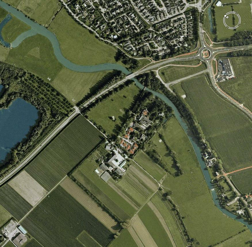
Thedingsweert, seen below in this aerial photograph, was where
the students who found the Aldenhaag fleece had their dormitory, and the
place where their walks began and ended. We first discuss Thedingsweert and
its history in section IIa, then Zoelen and the old castle mound at Aldenhaag
where the fleece seems to have been found in section IIb.
IIa. The Hamlet of Thedinghsweert
A smaller, less likely place for a Golden Fleece would be hard to imagine.
Today the town has 16 dwellings and some 54 inhabitants, and historically it
could not have been much larger. The aerial photo above (from GoogleEarth)
shows Thedinghsweert’s built-up area in the center, and a corner of Tiel
at the top. The river seen winding past Thedinghsweert is the Linge, a side
stream that drains the local land into the Rhine by the east side of Tiel. This
view also explains the importance of Thedinghsweert, since it covers the bridge
crossing the Linge and protects the backside of Tiel. The ancient fortification
was at the river end (East) of Thedinghsweert by the bridge. Faint outlines
of ancient buildings and constructions can be seen in the fields by the shadow
of their foundations. Early settlement was along the waterways, and most early
towns were built in a row along the water. Only in later years were towns consolidated
and walled in the more usual style.
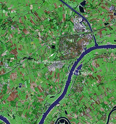 This
regional aerial view shows Buren, the district capital, in the upper left, Tiel
in he center and Thedinghsweert at the tip of the arrow, You can see how settlement
and farming followed the twisting waterways of the sodden, but rich, land.
This
regional aerial view shows Buren, the district capital, in the upper left, Tiel
in he center and Thedinghsweert at the tip of the arrow, You can see how settlement
and farming followed the twisting waterways of the sodden, but rich, land.
 Thedinghsweert
is located at 51ş52'53.05" N, 5ş24'8.65"E and at an elevation of only
2 meters, although it is halfway across the Netherlands in the Buren district.
The earliest mention of Thedinghsweert is in 1329 when it was owned by the Abby
of Thorn, a nearby foundation in Brabant some 50 miles to the south, when it
was known as Tetinxweert. Thereafter it became a feudal property and had a fortified
structure built on the land. In the early 16th century the area became part
of the domain of the van Egmonds, Counts of Buren, and Thedinghsweert may have
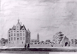
passed into the personal hands of the van Egmond rulers. At left is one artist’s
imaginary idea of the Thedingsweert castle in the 18th century based on other
Dutch small castles, although we have no certain information about the style
and appearance of the castle, or even at what date it vanished.
Thedinghsweert
is located at 51ş52'53.05" N, 5ş24'8.65"E and at an elevation of only
2 meters, although it is halfway across the Netherlands in the Buren district.
The earliest mention of Thedinghsweert is in 1329 when it was owned by the Abby
of Thorn, a nearby foundation in Brabant some 50 miles to the south, when it
was known as Tetinxweert. Thereafter it became a feudal property and had a fortified
structure built on the land. In the early 16th century the area became part
of the domain of the van Egmonds, Counts of Buren, and Thedinghsweert may have
passed into the personal hands of the van Egmond rulers. At left is one artist’s
imaginary idea of the Thedingsweert castle in the 18th century based on other
Dutch small castles, although we have no certain information about the style
and appearance of the castle, or even at what date it vanished.
The 16th century was a violent and difficult time for the Netherlands, with
civil wars between the Hooks and Cods, the Gelders Wars, dynastic wars as the
ruling family of Holland declined, and then the Habsburg and the religious wars.
Ruled by the counts of Buren, who still had to besiege Tiel in 1528 to control
it, the region remained in Habsburg catholic control as the revolt of Holland
began. It was seized by the Protestants under the Prince of Orange in 1572,
and harried and burned all about by the Spanish army under the Duke of Alba
in 1575. Thedinghsweert itself seems to have been burned and then rebuilt at
this time, but afterwards the region settled down to a quiet life as a rural
Dutch manor. The Counts of Buren died out and the land passed to the Prince
of Orange, later the Dutch royal family. In the late 1600s it was sold to Willem
Frederik van Brakell, and it seemed to have remained in his family for a long
while.
In 1795, during the French Revolution and its war in the Netherlands, there
may still have been a fortification there, but certainly a manor house. We have
a first hand account of the burning of Thedingsweert by English soldiers in
1795, so after that date no castle would remain. By late in the 19th century
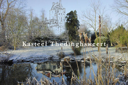
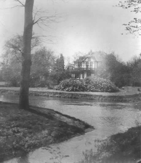
it was seemingly in ruins or worse, and in 1905 the wealthy van Beuningen family
purchased the estate and built a stylish country home there (seen below left
in a 1925 photo) next to where the old castle was located. They were patrons
of the arts and built up a major painting collection later donated to a museum.
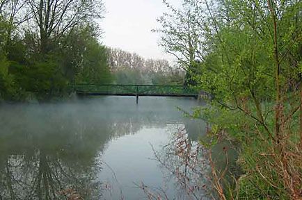
They also created a Monet-like pond and bridge from the Linge (seen below
right).
Today, although the Biologisch Dynamische School, Warmonderhof has left for
one of the new Zuider Zee polders, Thedinghsweert is still home to a gluten-free
organic bakery, some biologisch dynamische farmers on 55 hectares, and a school
to help the handicapped, as well as 56 inhabitants. One of the most positive
and amazing things about Europe is that urban areas end very suddenly, and farms
can be across the street from the town. Avoiding urban sprawl is such a saving
of good land.
Thedinghsweert Links:
Thedinghsweert Association
Zorgboerderij-bakkerij Thedinghsweert
IIb. The Hamlet of Zoelen-Aldenhaag
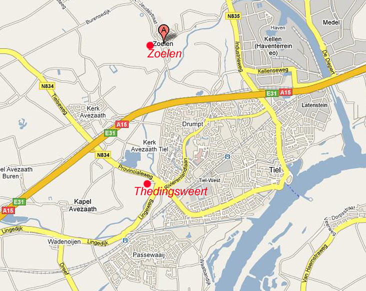
Only some 2.5 km. north of Thedingsweert lies the even older village and castle
at Zoelen, also on the Linge. The map above shows the relationship of Thedingsweert,
Zoelen and Tiel. In the 16th century Tiel was only the tiny area on the river
that encloses its name, and Zoelen was a half hour walk away. First mentioned
in 1263, when the area was known as Avezaath, it was divided into Aldenhaag
and Zoelen around 1300. Aldenhaag included the old motte and bailey fort and
its surroundings, and Zoelen was a manor house 500 meters away. Before the modern
period Aldenhaag was called the Esschenterp, literally "mound in between
the arable lands". It may be noted that Thedingsweert, Zoelen and Tiel
all lie on the north bank of defensible rivers since the threat in that period
came from the Counts of Flanders, who were attempting to seize the region, much
as the Spanish would try 300 years later. The area was devastated by the Count
of Flanders between 1290 and 1296, so the fears were well founded. By 1362 the
original castle on the motte had disappeared and the property of Aldenhaag was
divided from the newer castle land at Soelen. Originally in the hands of the
van Benthem family, by 1506 Soelen belonged to the van Rossums and then by marriage
with Heilwich van Rossum it came to Dirck Vijgh, the son of Claes Vijgh, in
1569, reuniting the two estates. Claes Vijgh (1505-1581) was a member of the
new burger aristocracy and was an active supporter of the Habsburg policies.
With Claes Vijgh’s 1530 marriage to an illegitimate daughter of Charles,
Duke of Gelderland the Aldenhaag property was part of her dowry, and was raised
to a noble fief ennobling Claes, who was thereafter known as Lord of Soelen
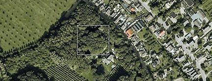
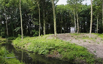
and Alden Haag. Below is an aerial photo of the site, with the old, tree
covered motte of Alden Haag in the white box, and the modern house of Soelen
at the lower right corner of the box.
 From
Claes Vijgh it passed to his son Diederick and so down the generations until
Karel Vijgh died without heirs in 1682. It then came into the hands of the van
Renesse family and in 1702 to Karel Pieck. On 22 June 1775 the property was
purchased by Johan Verstolk, a wealthy Rotterdam shipper and remained in his
family until 1845. When Verstolk acquired the lands it was described as a castle
on the Linge, having gardens, an orangerie, a barn with stalls and room for
carriages, farm buildings and was solidly built of stone and wood. The picture
to the left of Soelen in 1728 gives a good idea of what it looked like then.
The Verstolks were made noble as barons for their service to the state, and
the last of them, Baron J.G. Verstolk, was buried in 1845 in a small tomb on
the raised motte of the ancient castle. Baron Verstolk was both a Provincial
Minister and Minister of State and negotiated the independence of Belgium from
the Netherlands. Thereafter the property ran down and by 1900 was a restaurant
and guest house and was in poor condition and much changed for its new purpose.
In recent years it has been restored.
From
Claes Vijgh it passed to his son Diederick and so down the generations until
Karel Vijgh died without heirs in 1682. It then came into the hands of the van
Renesse family and in 1702 to Karel Pieck. On 22 June 1775 the property was
purchased by Johan Verstolk, a wealthy Rotterdam shipper and remained in his
family until 1845. When Verstolk acquired the lands it was described as a castle
on the Linge, having gardens, an orangerie, a barn with stalls and room for
carriages, farm buildings and was solidly built of stone and wood. The picture
to the left of Soelen in 1728 gives a good idea of what it looked like then.
The Verstolks were made noble as barons for their service to the state, and
the last of them, Baron J.G. Verstolk, was buried in 1845 in a small tomb on
the raised motte of the ancient castle. Baron Verstolk was both a Provincial
Minister and Minister of State and negotiated the independence of Belgium from
the Netherlands. Thereafter the property ran down and by 1900 was a restaurant
and guest house and was in poor condition and much changed for its new purpose.
In recent years it has been restored.
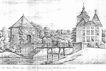 The
property lies on the Linge River (or stream) and is moated for defense, being
accessed by a gatehouse over the Linge as seen at the right in a 1728 print.
The old castle site of Alden Haag is also moated and not easy of access. Even
after the destruction of the first castle some manner of strong room was likely
built there to safely store valuables. One had to not only penetrate the first
moat and the castle of Soelen, but then go 500 meters through the woods to a
second moated location.This is possibly why the Vijgh Aldenhaag fleece was found
in the area of the motte, having been lost during the Spanish destruction of
1574, but the actual reason for the fleece being there is unlikely to be known
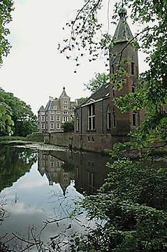
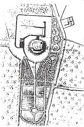
beyond reasonable conjecture. Below are photos of the motte at Aldenhaag
with Verstolk’s tomb, of the Zoelen castle today and a plan of Zoelen
in 1728.
The
property lies on the Linge River (or stream) and is moated for defense, being
accessed by a gatehouse over the Linge as seen at the right in a 1728 print.
The old castle site of Alden Haag is also moated and not easy of access. Even
after the destruction of the first castle some manner of strong room was likely
built there to safely store valuables. One had to not only penetrate the first
moat and the castle of Soelen, but then go 500 meters through the woods to a
second moated location.This is possibly why the Vijgh Aldenhaag fleece was found
in the area of the motte, having been lost during the Spanish destruction of
1574, but the actual reason for the fleece being there is unlikely to be known
beyond reasonable conjecture. Below are photos of the motte at Aldenhaag
with Verstolk’s tomb, of the Zoelen castle today and a plan of Zoelen
in 1728.
I. The Aldenhaag Fleece
III. The van Egmonds, Claes Vijgh & The Golden
Fleece
IV. The Standing Ram Fleece & Charles V
V. Documentation & Photos
VB. Documentation & Photos II
Appendix 1. The Standing Ram Fleece As Seen in
the Insignie Orden Book & Other Catalogs
Appendix 2. Other Scholars Look At the Aldenhaag
Fleece
Appendix 3. Greek & Roman Mythology of the Golden
Fleece
3B. Classical Texts
That Mention the Golden Fleece
May 2010 Meeting on the Aldenhaag Fleece — 1. The
Places
May 2010 Meeting on the Aldenhaag Fleece — 2.
The Fleece
Bibliography
Return to Society of the Golden Fleece
Return to the Golden Fleece Insignia Page
Antiques AtoZ Home Page
Medals, Orders
& Decorations